What Is Digital Image Processing (DIP)??
>> Saturday, 13 October 2012
Digital image processing focuses on two major
tasks
- Improvement of pictorial information for human interpretation
- Processing of image data for storage, transmission and representation for autonomous machine perception
Some argument about where image processing ends and fields such as image analysis and computer vision start.
The continuum from image processing to
computer vision can be broken up into low-, mid- and high-level processes
History of DIP
 1960s: Improvements in computing technology and the
onset of the space race led to a surge of work in digital image processing
1964: Computers used to improve the quality of images of the moon taken by the Ranger 7 probe
Such
techniques were used in other space missions including the Apollo landings
One of the most common uses of DIP
techniques: improve quality, remove noise etc
Example OF DIP USE IN GIS:
Geographic Information Systems
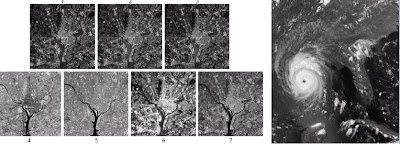
- Digital image processing techniques are used extensively to manipulate satellite imagery
- Terrain classification
- Meteorology
- Global inventory of human settlement
- Not hard to imagine the kind of analysis that might be done using this data
Check out this link below to know more About Digital Image Processing And Digital Image Processing using ERDAS Imagine
http://gisknowledge.net/topic/imagine_training/erdas_imagine_information_extraction.pdf


0 comments:
Post a Comment